

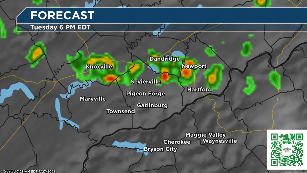
A semi-urgent weather heads up for Tuesday: Heat, humidity and the potential for stronger thunderstorms will impact parts of the Smokies region.
From the Smokies.LIVE Storm Center
Meteorologist Kyle Grainger
Storms will be hit-or-miss, but some could become strong to severe Tuesday afternoon and evening. The biggest concern will be gusty winds, heavy rainfall and lightning.
⚠️ Tuesday Storm Timing
- Morning: Hot and humid with patchy fog possible in mountain valleys.
- Afternoon: Storm chances increase, especially after 2 p.m.
- Evening: This is the timeframe to watch for stronger storms.
- Storms gradually weaken overnight, but a few showers may linger.
🌩️ Possible Storm Impacts
A few stronger storms could bring:
- Strong wind gusts
- Frequent lightning
- Heavy downpours
- Brief visibility issues while driving
- Isolated flooding where storms repeatedly move over the same area
🔥 Heat & Humidity
- Tuesday will be one of the hottest and most humid days of the week.
- Heat index values could reach the upper 90s to low 100s.
- Take breaks, stay hydrated and use extra caution if spending extended time outdoors.
📍 Tennessee Side of the Mountains
Gatlinburg | Pigeon Forge | Knoxville
- Periods of isolated to scattered showers and storms continue through Tuesday.
- A few storms could become strong to severe Tuesday afternoon and evening.
- Main threats: gusty winds, lightning and heavy rainfall.
- Not everyone will see a storm, but storms that develop could quickly become impactful.
📍 North Carolina Side of the Mountains
Cherokee | Maggie Valley | Waynesville
Tuesday will be a hot and stormy afternoon, especially after 4 p.m.
Forecast:
- Showers and thunderstorms likely, mainly after 4 p.m.
- Patchy fog possible before 9 a.m.
- Partly sunny skies early with a high near 91°.
- Heat index values could reach 100°.
- Storm chance: 60%
- Winds may increase during storms, with gusts up to 20 mph possible.
Tuesday Night:
- Showers and thunderstorms likely before 11 p.m.
- A chance of showers continues through the overnight hours.
- Low around 68°.
- Additional rainfall amounts generally light, but higher amounts are possible in thunderstorms.
🌤️ Looking Ahead
The good news: the pattern begins to improve after Tuesday.
- Drier conditions return mid to late week.
- Humidity levels gradually decrease.
- More comfortable weather arrives for outdoor plans.
Smokies.LIVE Storm Center Reminder: Tuesday is not a complete washout, but it is a day to stay weather aware. If you have outdoor plans, keep Smokies.LIVE Radar nearby and have a plan to move indoors if storms approach.
The Smokies.LIVE Storm Center is following the threat for severe storms on Tuesday. The primary threat will be Tuesday evening.
One response
Thank you Kyle for our Weather report