

Scattered to numerous showers and thunderstorms are expected through the weekend, with localized flooding possible where storms repeatedly track over the same areas.
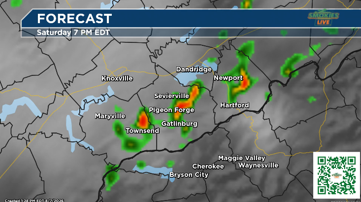
GATLINBURG, Tenn. (Smokies.LIVE Storm Center) — Meteorologist Kyle Grainger says Saturday morning should offer better weather across the Smokies before showers and thunderstorms become more likely during the afternoon.
Scattered to numerous showers and storms are expected over the next couple of days, with temperatures staying near normal for early August.
The biggest concern will be localized flooding, especially where storms move slowly or repeatedly track over the same areas.
Gatlinburg and the Tennessee Smokies
Saturday will start mostly sunny, with a 40% chance of showers and thunderstorms mainly between 2 and 5 p.m. The high will be near 89, with heat index values reaching as high as 97.
Saturday night will be quieter, with only a 10% chance of a shower or thunderstorm before 7 p.m. The low will be around 70.
Sunday will bring another chance for showers and thunderstorms, especially from late morning through the afternoon. The high will be near 90, with heat index values as high as 98. The chance of precipitation is 50%.

Bryson City and the North Carolina Smokies
Weather conditions will be cooler and wetter around Bryson City.
Saturday brings a 70% chance of showers and thunderstorms, mainly between 2 and 4 p.m. Patchy fog is possible before 10 a.m., followed by partly sunny skies and a high near 79.
Saturday night will be partly cloudy, with a 30% chance of showers and thunderstorms, mainly before 7 p.m. The low will fall to around 64.
Sunday will feature a 60% chance of precipitation. A slight chance of showers is possible before 11 a.m., followed by showers and thunderstorms through the afternoon, with showers likely and possibly a thunderstorm after 5 p.m. The high will be near 81.
Sunday night will be partly cloudy with a 30% chance of thunderstorms before 8 p.m. The low will be around 64.
Smokies.LIVE Storm Center
If you’re making plans this weekend, Saturday morning looks like the better window for outdoor activities, but keep an eye on the sky as storms become more likely during the afternoon.
Remember, even if your location is dry, storms nearby can produce heavy rainfall and lead to localized flooding downstream.
Stay weather-aware and keep the Smokies.LIVE Radar handy throughout the weekend.

No responses yet