

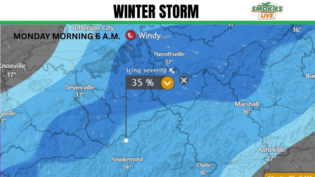
(SEVIERVILLE, Tenn.) SMOKIES.LIVE – Thursday evening update comes with a wedge of warm air trying to nudge right over Knoxville warming us just above freezing on Sunday. This will limit the amount of snow we will see accumulate.
We will start on Saturday morning with snow and transition to rain by Sunday morning. Sunday night we’ll transition back to snow for the start of Monday before clearing out in the afternoon.
Friday will give us a clear look at what will happen. We’re starting to get more hourly updates with data.
ESCAPE THE COLD INSIDE WITH SOME WATER PARK FUN THIS WEEKEND

PREVIOUS COVERAGE
As we have been talking about for days, I believe we have a major icing event for East Tennessee and Western North Carolina. There are indications that it could be more freezing rain than snow, but don’t let that fool you.
Ice is tremendously dangerous and can lead to significant power failures across the area. You may see a blanket of snow, but is that ice underneath? That’s what you need to think about over the coming days.
Thursday is the time you need to get your plans in place. This is gather all the food you need for 3 days, plan on where elderly relatives are going to go and find all your winter gear.
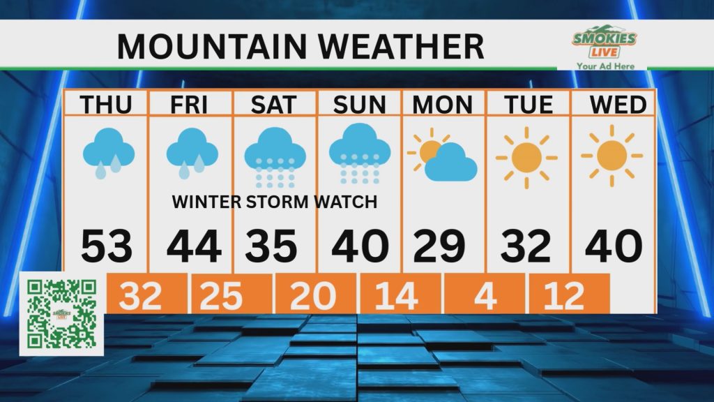
A Winter Storm Watch is posted from Friday night to Sunday evening for widespread freezing rain, sleet and snow. It will transition from time to time between the three. It will be more difficult to see icy spots at night, making driving even more dangerous. All travel should come to a close by midnight on Friday when I believe the temperature will drop below freezing for all.
If you are visiting the Smoky Mountains, talk to your property and find out their best advance for your continued vacation. If you are in a cabin on a mountain top, you should consider moving into one of the cities for the remainder of your stay. It will be difficult for roads to be maintained at higher elevations.
After the precipitation ends, plan for an extended freeze. If there is a power failure, have a save way to heat your home.

PREVIOUS COVERAGE
A significant icing event is shaping up for the entire southeast and especially right in East Tennessee and Western North Carolina.
We’re starting to get a better handle on timing and impacts. Timing is still on track from Friday to Monday. For East Tennessee, we start on Friday with a cold rain. That rain will transition to freezing rain/sleet by the afternoon with a change over to all snow going into Saturday morning. This type of set-up means heavy wet snow will fall at first which adds to our “how much are we going to get?” question everyone wants to know. How quickly does the dry air mix in to get into that fine powder snow? That’s the question.
Sunday brings off and on bands of snow with everything finally tapering off on Monday morning.
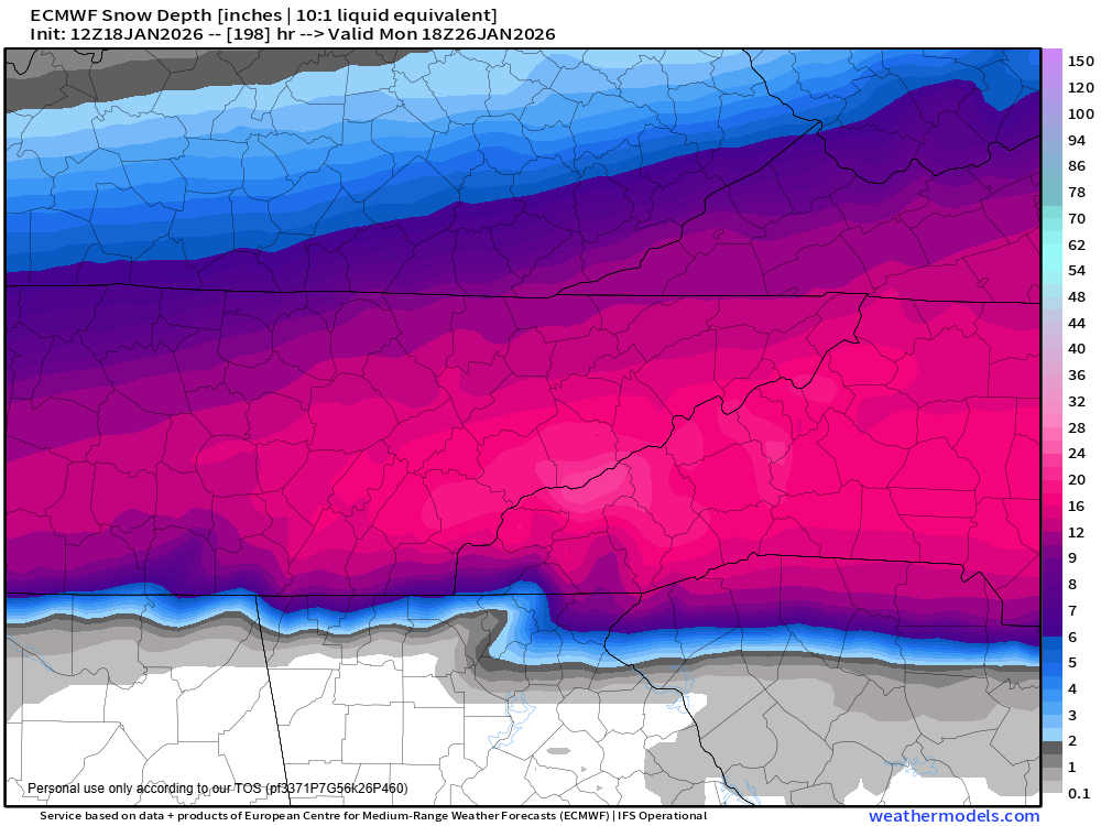
I would plan for a good quarter inch of ice in spots and up to 8″ at least of snow on top of that. The Great Smoky Mountains could get up to 2 feet without question.
WHAT SHOULD YOU DO NOW?
Re-evaluate your food and water supply. You should have at least a 3-day supply of non-perishable food and water (1 gallon/person/day).
Check on your neighbors and those less mobile. Where is your snow shovel? AND ice scraper? You may need to stock up on some deicer.
If you can, purchase supplies on Wednesday, but you’ll still have a chance on Thursday. It will just be wet. You can leave Thursday for a last-minute “oh I forgot.”
Check back for the latest weather updates. This is fluid and can and will change. Click around on Smokies.LIVE Weather page and see what the model is showing for your neighborhood.
The Smokies.LIVE Live Stream will run 24/7 with updates on the snow storm and impacts.
PREVIOUS COVERAGE
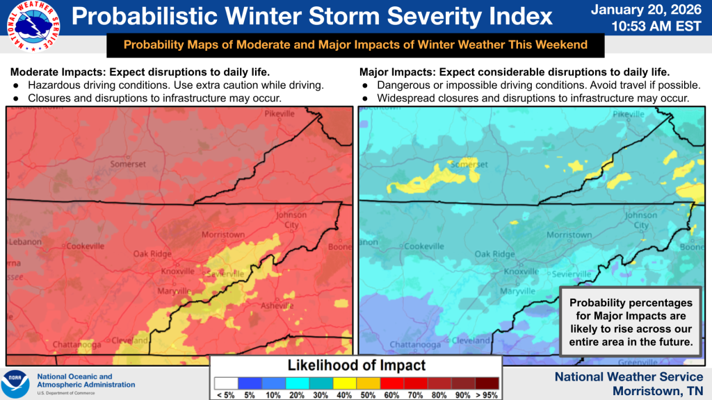
There’s more confidence Monday evening that the winter storm will develop and impact a large portion of the south this weekend. This impact will include all of Great Smoky Mountains National Park and the surrounding counties.
The region is on the edge of where the freezing rain and heavy snow line meet. At this point we need to monitor the changing situation and be ready to take action. Right now the timeline is from Friday to Monday where we need to stay alert.
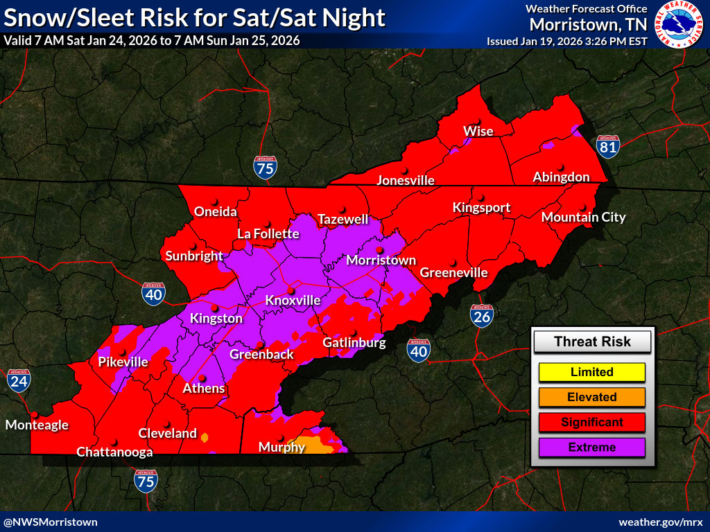
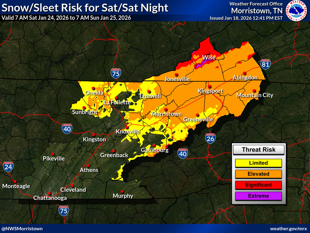
This information is shared for guidance only and not a specific forecast for the area. It is too early to talk about specific impacts. This is an awareness stage. This map was shared by the National Weather Service on Monday.
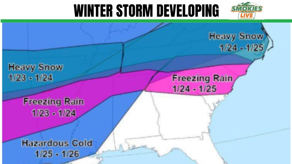
Once the moisture passes we will be left with a very cold air mass that settles in for much of next week. This will include an extended stretch where we may not get above freezing for days.
What should you do now?
- Keep checking back for weather updates.
- Think about how you will stay warm if power fails.
- Think about food ideas that won’t need to be heated.
- Check on neighbors.
- Where is your snow shovel? Do you have rock salt?
Smokies.Live Weather has current conditions and the extended forecast 24/7.
PREVIOUS STORY
Models are starting to find agreement that the Southeast could be in for a major winter weather event this coming weekend. Whether there is snow and ice or not, the consistent part of the forecast is an extended freeze is setting up for next week.
The potential is there for the coldest air of the season to arrive for next week, January 26 and beyond.
From freezing rain to snow with a surge of cold air in place, indications are leaning to a big event for the south Sunday. I do not share this to incite fear, but something to pay attention to as we move through the week ahead. Smokies.Live Weather has current conditions and the extended forecast 24/7. It is very rare that I would share this concern this far out.
The precipitation will start in the Tennessee area on Saturday with sleet and snow. Overnight as the air drops below freezing around 2 a.m. on Sunday morning we’ll see a change over to snow. This is likely to be the case well into Sunday as the moisture stalls out across the area into Monday.
The set-up currently keeps the freezing rain south of Knoxville and Sevier County with a snow event here. That being said, things can and will change up to one week out.
Even longer range models indicate some single digit low temperatures into the next week. Daytime highs will not get above freezing in some areas after Friday until Tuesday or Wednesday.
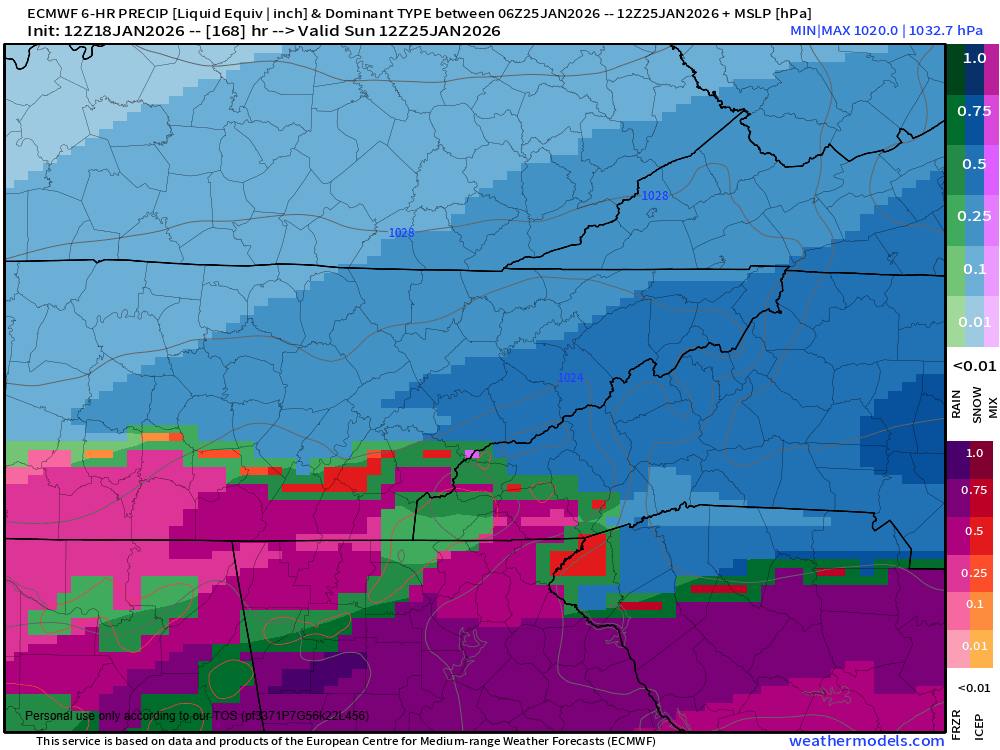
The model data shown is not a forecast but for reference of the set-up taking place across the south. Remember, the forecast can and will change, but it’s a reminder to keep checking back.
No responses yet